
Maps provides us with information regarding the changes occurring in our county over time. Things like street maps, political maps and topographic maps are all names we have probably heard before. That’s because they’re important and not only for historians. Street maps show us the evolution of our roadways and the changing shapes of our cities. Political maps show us the location of our cities and the shapes of our counties. Topographic maps show us how the very land has been shaped and reshaped over time with the influence of human populations. These all provide important information for daily use and historical information. Of course there are more types of maps then just these three and one in particular that is worth discussing for historical interest. That is the plat map.

Plat maps have a much narrower focus than any of the other maps already discussed. These maps cover only a small section of a city. Plat maps like this were made when a land owner or land owners had their land surveyed and divided into plots. Generally this land is sold to others plot by plot. For people interested in buying any of these plots, the plat map is useful for providing necessary information about what is available on those plots of land.
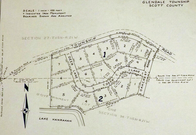
Looking at this closeup we can analyze the plots of a plat map more closely. Significant for every plat map is the compass as seen prominently displayed in the lower left of this image. This helps show how this map is orienting its depiction of the land and helps to more accurately determine how a plot of land is shaped when inspecting it. A plat map tells us the size of a plot. Looking at the plot in the upper left hand corner labeled with a 7, we see other little numbers running along the insides of the polygon. These numbers inform us that the southern side of the property is 166.90 ft., the eastern side is 135 ft., the northern side is 120 ft., and the western side is 142.92 ft. Prospective land owners are also given information such as how their property faces roadways and how lakes and rivers interact with plots. We can see here that plots 4 and 5 of the second section are lakeside properties, having borders along Lake Hanrahan. Plats also indicate if part of your land is designated as an easement. Depending on what type of easement your property has, the indicated section can be used for purposes other than the owner’s, such as building a new public roadway. So, for a potential land owner, a plat map can help you learn what you’re getting from a piece of land.

For historians, old plat maps provide a lot of information about ownership. For the two plat maps seen above, we are seeing the land as it was surveyed and originally divided into plots. Plat maps also provide us with the dates of when surveys of land took place as well as giving us the names of others involved in this whole process. The names of these original land owners can often be seen on street names in the neighborhoods that they once owned. If you’re ever wondering where a strange street name came from, it could very well be this exact situation.
As plots are sold the names of the buyers are included in future updates of plat maps. This way, by looking at plat maps you can learn the land ownership history of an area. This is useful for city or county history but could also come in handy for researching family history. If you’re looking for a plot of land that an old relative owned, find the right plat map and you’re on your way. So whether you’re a historian or a perspective land owner a plat map is a useful piece of information.
If you would like to learn more about map making or if you’re curious about the history of the city of Prior Lake has then visit the Prior Lake City Hall starting 8/11/2017 to see the exhibit Finding the Way: Map Making in Prior Lake.
Written by Tony Connors, Curatorial Assistant.